

Is software the answer to streamlining London’s convoluted planning process?
Technology is the key to a faster, efficient and more democratic planning system.
Planning is too often expensive, slow and fallible. The system can be viewed with suspicion by the public and hampered by the complexities of politics. But as populations grow, urban density increases and housing shortages bite it has never been more important. The planning process requires clear and detailed information from multiple sources. It needs strategic thinking and imagination, as well as the ability to persuade – all of which present their own challenges.
Software development and artificial intelligence are already having a tangible impact on all stages of the planning process. Technology is already starting to help streamline planning, making it quicker and less expensive. We have seen this ourselves with the adoption of VU.CITY by the majority of London boroughs, improving dialogue and promoting closer collaboration with project teams. But this is just the start and with technological advances much more is possible.
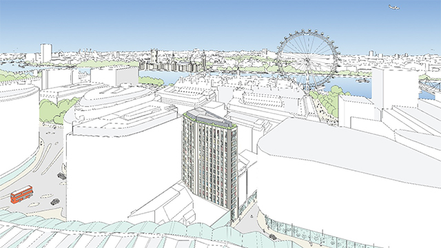
VU.CITY’s software platform enables technical and creative consultants to work together, designing and illustrating development plans in 3D within an accurate representation of the streetscape. Design changes can be tested quickly and feasibility assessed much earlier in the process, reducing the time and cost of numerous iterations. Furthermore, it makes creating images and testing different viewpoints far quicker and easier.
Currently, it is a laborious process, often involving someone physically walking the streets to take photographs. One London development required 80 pictures to cover all angles and viewpoints – more than half were to demonstrate that you couldn’t see the building from a particular position and several others that the effect was marginal.
Accurate 3D modelling enables this job to be done more quickly, cheaply and efficiently, creating a detailed visualisation that can be viewed from every window, not just street level. Bringing 3D visuals into the pre-planning stage can save months of discussions, eliminates the risk of misunderstanding and adds context.
It is also being used in the later stages of the planning process for public consultations and by planning committees, making visualising developments much easier for professionals and lay people alike.
The wider context
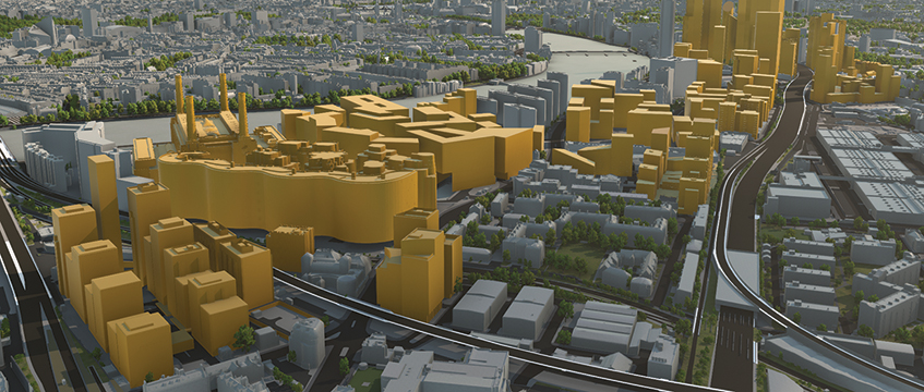
But where it is having the most impact is in helping to understand the effect a development has on the wider area. At planning committees where 3D modelling is used the focus shifts; questions are not only about what a scheme looks like but also about its impact and wider context. Two planning enquiries in Tower Hamlets were won with the help of VU.CITY’s 3D modelling platform because they enabled expert witnesses to give a much clearer and reasonable argument for densification.
And when you start plugging different data sets into the model, such as sunlight, traffic and pedestrian flow, you can assess the impact of multiple variables at the same time.
Virtual modelling allows you to show how the development will change an area and what that change means, which is a powerful tool. It can be used to help remove suspicion at public consultation and help generate positive engagement.
It also means you can open up consultations to a wider audience, putting interactive 3D visuals online or even in an app. Personal experience of public consultations shows that the wider the audience the more balanced the views.
Having access to more detailed information and in a clearer manner is also a step on the road to building trust. But could we take that one step further and democratise the planning process?
If we can determine how a city is going to change then we can involve not only the design teams but also help the public visualise and understand the wider impact of a development from the outset. We can create a tool that is accessible to all and allows people to view different simulations and comment at a much earlier stage.
Development and regeneration proposals therefore become more transparent, the public is included earlier in the process and can even help shape the plans into something that better meets the needs of the community.
Plugging in additional data sets – Land Registry, listed buildings, demographics, Section 106 proposals and transportation, to name a few – help people to see the bigger picture.
Reducing risk
In the longer term a collaborative tool could enable a different sort of narrative between developers and local authorities in which appropriate use is determined before land acquisition. It would facilitate more accurate pricing and create a level playing field. Of course, it wouldn’t work in all cases but anything that helps reduce risk in development and takes away some of the uncertainty has got to be beneficial to the speed and delivery of development.
In the short term, the goal is to grow the number of cities covered by VU.CITY beyond London, Manchester, Birmingham, Brighton, Belfast and Paris and increase the accuracy. Currently VU.CITY is accurate to 15cm at roofscape, making it the most accurate large-scale model of its type in the world. We want to develop that level of accuracy for the facades within the 3D model to make it even more realistic and have secured Innovate UK funding in order to do just that for the Square Mile.
Collaboration will further benefit the modelling platform and our aim is for existing tools such as public consultation platforms Commonplace and Built ID to be able to plug into VU.CITY. This is about shared information and opening access on a variety of different levels to ultimately generate more timely and relevant development.
London and growing cities around the world need to be sustainable, enjoyable places to live and work and an efficient and transparent planning system plays a big part in that. VU.CITY offers the Smart City Platform for that.
Jamie Holmes is chief executive of VU.CITY