

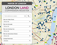
 London’s surplus public sector land has been identified on a digital map showing potential space to build at least 130,000 homes.
The map, published by the London Land Commission, shows all publicly-owned land, with details of each site’s holding name, tenure and size.
The register includes brownfield land owned by boroughs, the police, the National Health Service, military, transport agencies, government departments and other public organisations.
The so-called “third Doomsday book”, commissioned by Brandon Lewis and Boris Johnson, has revealed that 25% of London is owned by the public sector, comprising 40,000 sites.
It is now being analysed by City Hall to see how development can be unlocked.
The push to release public sector land for housing coincides with amendments to the Housing & Planning Bill which urge public bodies to maintain an up-to-date written record of property.
Writing in City AM, Richard Blakeway, deputy mayor for housing, land and property, said the register raised two challenges.
First, that development not be restricted to surplus sites, but include underused sites or land freed up through services co-locating.
Second, compulsory purchase powers should be strengthened so private land can be aligned with public land if there is potential for improved regeneration.
View the map >>
• To send feedback e-mail louisa.clarence-smith@estatesgazette.com or tweet @LouisaClarence or @estatesgazette